Area History
Blackwater and Hawley Town Council is situated in the North East corner of Hampshire, adjacent to the Surrey and Berkshire borders.
It is one of the 21 Parish and Town Councils in the Hart District and currently incorporates Blackwater, Hawley and Minley.
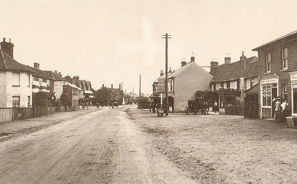 This part of Hampshire is rich in history and records go back to the reign of King John. The name then for Blackwater was “Bredeford” and in the Assize Accounts for 1281, mention was made of ‘payment of 23 pence for the expenses of men at Bredeford’. Exactly when and why the name changed to Blackwater is not known, but in later centuries it became an important coaching centre on the main highway from London to Exeter, then known as the ‘Exeter Road’. The ‘White Hart’ and the ‘Red Lion’ (now known as ‘Mr Bumbles’) were coaching inns of the 17th and 18th centuries; the latter still exists, but the ‘White Hart’ was demolished several years ago and is now replaced by the White Hart Parade building. In 1727 the London Road (now the A30) assumed its present route, the construction work being carried out by the troops.
Away to the West, on the Minley Road, still stands the ‘Crown and Cushion’, an inn where it is said some of Captain Blood’s accomplices were apprehended after his attempt to steal the Crown Jewels during the reign of Charles the First.
 By 1851, as a book by William White recorded, the tithing of Hawley had 850 inhabitants and several scattered farmhouses – with both a Post Office and a Station at Blackwater.
With over a thousand years of history surrounding the river crossing at Blackwater, known as Brydrs Ford (Brides Ford) from the Crondall Hundred survey of 973-974 AD – it seems reasonable to suppose that a major redevelopment alongside the bridge could well of be interest to historians.
Norah Hough’s booklet “I Remember, You Remember” records that in March 1645 during the Civil War, the Lord General’s Life Guards under Colonel Ludlow were camped in Blackwater and given orders to “hold in check the Royalist patrols from Basing”. A canon ball – relic from this time – was found amongst the foundations of the bridge.
At the time of the Blackwater Cattle Fair, renowned as the largest cattle fair in the South of England, it is said that pub windows were boarded up and sawdust laid on the floor and sacking hung on the walls as a measure of protection against rowdy drovers who were fearsome men indeed. Nora Hough’s booklet contains a very full account of the Blackwater Fair – the former Entecon building (now flats) stands on the site of the old fairground.
When the railway came, there was a level crossing at Blackwater with a small footbridge over the lines and a narrow bridge over the river. Toad Lane was always used as a short cut to Camberley and ran from Vicarage Road, through kissing gates either side of the railway then across the river bridge, originally erected in 1805-06.
The map dated 25th August 1817 currently located in the Meeting and Conference room at the Hawley Memorial hall, is a monumental piece of work for it actually records the owners of every plot or piece of land within the then whole parish of Hawley, with their acreage, position and boundaries, and all the public and private roads and rights of way.
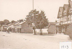
In 1891 the population of the Parish was 998.
In 1912 a census was taken for the Rural District Council of all traffic passing over the Blackwater River Bridge on Saturday 25th May 7 am to 10 pm and it is interesting to read the results.
2,505 Pedestrians – 141 had perambulators or handcarts.
1,671 Cycles – 6 were tandems.
348 Light vehicles – 22 with horses.
152 Heavy vehicles – 4 with two horses, one with three horses.
296 Motorcars.
9 Heavy traction engines – two with cartage trucks.
165 Motorcycles – 37 with sidecars.
44 Horses – either led or driven.
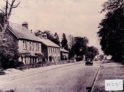 The London Road has been a busy highway for many years and on Bank Holidays the cars would be lined up as far as the eye could see when the level-crossing gates were closed against them, and it was the done thing to go and ‘watch the traffic’.
For pedestrians it was a very dangerous road to cross, as there were no bollards or islands in the centre on which to take refuge, one literally took ones life in ones hands and dashed across.
During the later part of the 1920’s traffic increased to such an extent that it became dangerous to cross the river bridge on foot so a temporary wooden bridge was erected along the outer wall. The present bridge was opened in 1930. All the gravel to build it was taken from the gravel pits in Rosemary Lane (now Foxley Close and Beaulieu Gardens) hand dug and hand loaded onto a continuous stream of lorries and carts, which brought it along the lane, this was a country lane then with high hedges and fields on either side. The same gravel pits were used to supply material for the “New College” at Sandhurst (Military College).
The river bridge is the point where three counties meet – Hampshire, Surrey and Berkshire; each county paid a percentage of the cost of the construction.